
 |
 |
|
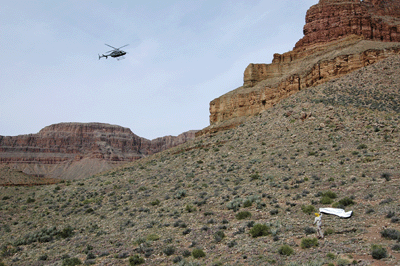
We heard the helicopter before we saw it. The whip-slapping sound of the propellers seemed to come from the direction of Hermit Canyon. And then it was there, scudding towards us just above the rim, then dropping below the rim and approaching from the southwest. Chris Forsyth grabbed his tarptent and held it overhead, letting the wind snap it taught. The giant wind sock flapped and fluttered in the gust. The helicopter zipped overhead from west-to-east, then circled back and hovered long enough for a ranger to indicate with hand signals that we should clear the landing area. Settling gently atop the Tonto, the giant propeller slowed its churning. Two rangers emerged walking calmly and confidently towards our location among the boulders; the only place within eyesight offering shade on this warm March afternoon.
This was the eighth day of our hike and we had hoped to reach Phantom Ranch by nightfall. But when I heard Dennis groaning in agony and turned to see how gingerly he was favoring his left foot, thoughts of a cold Phantom Canteen "Lemmy" were immediately replaced by concern for my friend. The night before, we'd camped at the small sandy beach at Ninety-four Mile Rapids. As had been our habit for much of the hike, we'd awoken at 4:30 am, made breakfast, struck camp and were on the trail by about 6:30. A cairned trail had led us from the mouth of Ninety-four Mile Creek up onto a shelf. From there, we'd trekked upstream as far as the route would go. It had led to a fault ravine that others, before, had used as a route from river to Tonto.
Early in that climb, Dennis Foster had rolled his left foot and stumbled backward in pain. Was it a sprain or a break? We didn't know. What we did know, was that it was time to keep our wits and think through the options. Chris and I continued up the fault ravine to the rim. John Eastwood stayed with Dennis to assist him in the climb to the rim. About two-thirds of the way to the top, Chris and I stopped at an open area where ancient ruins blended into the base of a perforated rock wall. Chris left his pack, here, and returned to get Dennis's pack. I continued to the rim, shed my pack and returned for Chris's. By the time all of us had reached the Tonto level, it was 10:00 am and the sun was high in the southeast sky.
Dennis tried hiking. He used his hiking pole for support but the uneven terrain constantly worked against him. We only managed to cover 1/4-mile in about 45 minutes and stopped in the shade of some boulders to assess the situation. Dennis removed his boot and sock, revealing a swollen foot with mild discoloration beginning go set in. At best, this was a serious sprain. At worst, there was a broken bone or a torn ligament. Whatever the case, Dennis was not going to make Phantom Ranch today; perhaps, not in two or even three days. There was no readily available water and we were about the enter a bay below Tower of Set. Once in there, the only way help would be able to reach us would be on foot. No, if we were going to call for assistance, this was the place and now was the time.
Chris had been using his SPOT satellite messenger unit to send regular location updates to his wife, throughout the trip. SPOT is a nifty little device. It's about the size of a handheld GPS unit and communicates to the outside world via the Globalstar satellite network. SPOT offers three message options. "OK" sends a message to several email accounts keeping family and friends informed of your progress. "Help" lets people know that you're in trouble, but are managing and not in immediate need of assistance. "911" is the button of last resort; to be used only when in need of immediate assistance.
In our situation, self-rescue was not a realistic option. Dennis's possibly broken foot needed immediate attention so, the decision was made to hit the "911" button. About two hours later, help arrived on a National Park Service helicopter. The rangers--Brandon and Jessica--assessed the injury and decided to airlift Dennis to the park clinic on the South Rim. Within thirty minutes, Dennis was strapped in and the great bird was lifting off for the return flight. Minutes later, a medical doctor would be examining the foot. This left me, Chris and John to finish the hike. We had been a day behind schedule at the start of the day. Now, having lost several hours to the injury and rescue, we were another half-day behind. Oh well, that's hiking in Grand Canyon for ya.
The trip had begun, well enough, the previous Saturday. We'd gotten an early start from Flagstaff, taking Highway 89 north to Jacob Lake. From there, we were able to follow the winter access forest road to within about 2 miles of Big Saddle Point at the head of Crazy Jug Canyon. Dennis's wife and stepson had joined us for the drive to the North Rim. With the four of us and our gear removed from the vehicles, Cara Lynn and Eric began the return trip to Flagstaff. Along the way, they would leave Chris's vehicle at the Bright Angel Trailhead. Over the next week or so, we would follow a route and itinerary that Dennis had been trying to do for the last two years.
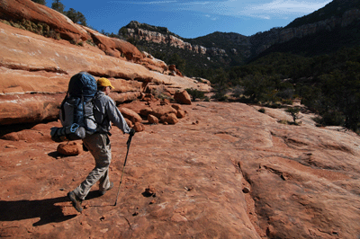
He and I were going to do this hike during Spring Break in 2008. However, I'd had to cancel for surgery on my right knee and the heavy snows of that winter had shut down access to the North Rim. This year, my knee was fully recovered and the weather cooperated wonderfully by serving up sunny days and moderate temperatures for our hike. We got to the Crazy Jug Trailhead just before noon and were soon following an apparently well-groomed trail. As with the itinerary, the fine condition of this trail was largely due to Dennis's effort. He'd found this long-disused trail some years back and had made several return trips over the years to clear brush and restore the trail to a usable condition. The restored trail took us by an old, cement water trough and an overhang at the Toroweap/Coconino boundary marked with an ancient pictograph.
Once through the Coconino, we were treated to some classic Esplanade level slick rock hiking...for a couple of hours until the manzanita fields appeared. The dense manzanitas and thorny shrubs made the first two days of the hike a real slog. There were no established trails or cairned routes through much of Crazy Jug or Saddle Canyon. The views were spectacular but the going was slow. We camped that first night at the Esplanade level south of Timp Canyon, having covered approximately 7.5 miles since leaving the vehicles.
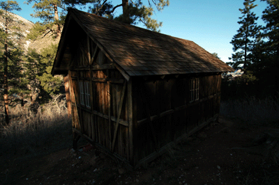
Our progress improved as the dense thickets abated the morning of the second day. Below Timp Point, we were treated to an unexpected yet fine view of Thunder river. Looking west through Tapeats Creek Canyon, Dennis spotted the white gush of water pouring from a cave in the cliff face. It was even more impressive through my mini binoculars. After lunch in Stina Canyon, the dense manzanita fields again slowed our progress. Eventually, we decided to head down into Saddle Canyon Creek and a known route to the Muav Saddle ranger cabin. Finding running water in Saddle Canyon, we filled our bottles and bladders before moving on. Lingering snow from December storms made for cold, wet hiking and faint trails as we worked our way up Saddle Canyon. Eventually, we found the trail to the cabin and entered its warm confines just after 6:00 pm.
It was nice to be out of the cold for a night. And the rustic two-room shelter appeared to be in relatively good condition considering it has been many years since this cabin was in regular use. Chris and John took bunks in the back room. Dennis and I were comfortable on the floor of the main room. The only discomfort I had the first two nights was due to cold. I had packed my Big Agnes Cross Mountain 40 as a weight-savings measure. Sleeping in long johns with foot warming chemical packets adhered to my socks had made the first two nights bearable. Afterwards, the Cross Mountain would prove to be just right for the nighttime temperatures we experienced the rest of the trip.
On day three, we followed the North Bass Trail from the Muav Saddle cabin to Shinumo Creek near the Colorado River, a distance of about 11 miles. Compared to our progress the first two days, we were practically flying through Grand Canyon. The spring thaw had primed springs and filled drainages. Much of the day, we were no more than a few minutes from water. The Supai traverse above the west rim of the Redwall gorge offered stunning views. We stopped for an early lunch at a shady spot in White Canyon below Emerald Point. Shortly after lunch, we passed a tempting waterfall that emptied into a pool that appeared to be every inch of 10-feet in depth. This would have been desperately enticing on a hot summer afternoon. It was about 1:00 pm when we arrived at the junction with the major drainage southwest of Emerald Point. Another hour of hiking brought us to the recently improved high bypass route to Shinumo Creek. This wide, easy-to-follow track allowed us to stretch our legs and hike at a good pace. The views of Holy Grail Temple to the east, Masonic Temple to the west and Dox Castle to the south were inspiring. Ninety minutes later, we descended into Shinumo Creek which was swollen with water.
After tanking up on water, we continued downtrail. A large boulder at a place where the creek was running swift and deep held us up for a bit. But we eventually found a cairned bypass around and above the boulder. William Wallace Bass operated a tourist camp in this area. His camp was complete with an orchard populated by fig, peach and apricot trees. Today, an impressive display of artifacts reminds us of the history of Shinumo Camp and Bass's impact on this place. We passed a Sterling brand pot-belly stove just north of Bass's camp. The collection of artifacts on display at the camp itself included housewares, cowboy tools and other odds & ends. Continuing downtrail to find a campsite for the night, we passed a boulder with an inscription signed by a man named, Vaughan, who was apparently from the town of Claude, Texas. The inscription is dated September 11, 1912.
The next day was most challenging for me. We had set a goal of reaching Monadnock Amphitheater by nightfall, estimating the distance at 7 miles. That may not sound like much but the day would feature three significant up & down climbs, including one that started the day. The first order of business was a trek up and over a schist outcrop to Shinumo Rapids. A river party was camped at the beach and a couple of rafts were already in the water by the time we hiked past the junction with the trail to the river. We waved but didn't stop to chat. We continued on the cairned trail to Hotauta Canyon. From here on out, we would be completely off-trail for the majority of the trip. We did a second up & down climb over a hump into Hotauta. Then, we negotiated a route up through the Tapeats to the Tonto level above Hotauta. The climb to the Tonto really took a lot out of me and, for the remainder of the day, I was low on energy.
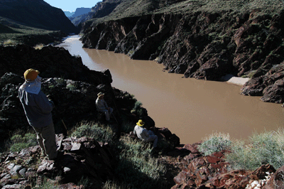
As mentioned previously, William Wallace Bass had a going tourism operation in this part of Grand Canyon during late-19th and early-20th centuries. He constructed a tram system for transporting customers and supplies from one side of the river to the other. We first spotted the remains of the tram on the south side of the river. Then with a little investigation, we found the battered remains of the tram on our side. Chris and I stopped to have a look and take a few photos. We also spotted the trail leading from the Tonto level on the south side of the river to Bass's boat beach. And later, Chris pointed out where the Ross Wheeler, an boat built by river runner Bert Loper and abandoned in place above Bass Rapids. It is these ocassional encounters with ruins and relics that keep me coming back for more in Grand Canyon.
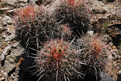
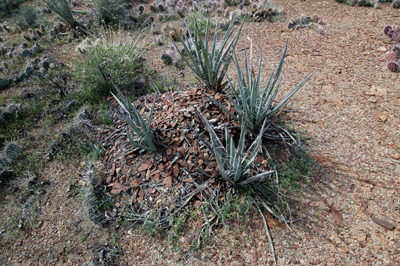
It was just after 11:30 am when we topped out on the Tonto. Much of the rest of the day would be spent hiking around the minor bays and drainages below Evans Butte. Evans Butte is a flat top mesa and the northern-most feature off Sagittarius Ridge. Hotauta Amphitheater drains to the west from Evans. Monadnock Amphitheater drains to the south-southwest. In between, lies a major but unnamed drainage. The rolling terrain was quite different from anything we'd experienced the first three days in the Canyon. There were no more manzanita fields, no forest trails choked with snow and a bone dry desert had replaced the verdant creekbeds of the North Bass. But the Tonto offered its own challenges and rewards. Drainages and bays required downclimbs on approach and upclimbs in search of game tracks on exit. The wide open plains were often choked with cactus fields requiring constant attention to where the next bootstep landed. And there was the ocassional reminder that this arid desert environment can be deadly, usually in the form of bones bleached white by the constant, beating of the sun. Among the rewards, were broad expansive views through the length and breadth of the Canyon. And there were tantalizing hints of ancient human occupation of this area; the rare mescal pit or carefully placed stone step that made exit from a drainage less demanding.
In fact, it was an encounter with a cactus that added the exclamation point to this day for me. We were hiking up slope to gain a better approach angle into Monadnock when a bowl-shaped bundle of grass caught my eye. Walking past, I stared at the bowl and thought, "Could that be a bird's nest?" It was a minor distraction but I took my eye off the trail long enough for my foot to catch on a stone, which caused me stumble and fall. The fall was harmless enough; I landed on my behind with embarrassment being the only injury. Or so I had thought. Soon, I felt the telltale tingling of cactus needles poking into my flesh. Standing up, Dennis and John saw the real problem; a backside covered with spiny needles. You learn who your friends are on a hike of this length. And for the next half hour--with me bent over a boulder and naked from the waist down--Dennis and John used tweezers to pluck needles from my buttocks. I was with good friends on this trip.
My cactus encounter happened at about 2:45 pm. The delay meant we would be contouring through Monadnock in late afternoon. We turned the corner into this large amphitheater at 3:45 pm and began walking along the rim in search of water. We were counting on finding springs or pothole water in Monadnock drainage but the creekbed looked bone dry from our vantage point. Making our way deep into the amphitheater to the head of Monadnock, we descended into the creekbed and hiked downstream to the junction with a drainage coming in from the left. This is where we would exit the canyon back up to the Tonto level in the morning. But for now, our real need was water. Dennis and Chris collected our empty bottles and bladders, and began hiking downstream. Their plan was to go all the way to the river, if necessary, to collect enough water for the evening and following morning. John and I stayed with the gear and scouted the area for suitable locations for tents and sleeping bags. Thirty minutes later, Dennis returned with news that he and Chris had found a spring just a few minutes downstream. Chris was filtering water but my MSR MiniWorks filter was having problems. I hiked down to where Chris was and managed to get my filter working well enough to process about 2 liters before dark.
This night was typical in that I made and ate dinner in the dark, before turning in early for the night. My nightly routine was pretty simple: dinner consisted of a Mountain House ProPak single-serving meal. My favorites are beef chilimac, lasagna with meat sauce and chicken teriyaki. To the 12-14 ounces of water needed for the meal, I would add another 8 ounces for a cup of hot apple cider. I always look forward to the tangy, sweet taste of the cider with dinner. Dessert consisted of a snack size Hershey bar with almonds. After dinner, I would take care of some housekeeping, such as cleaning my camera and glasses, applying fresh mole skin to hot spots and developing blisters, and making the nightly entry in my hiking log. These tasks took about an hour and were often done in the privacy of my tent. It was a relaxing way to end each day.
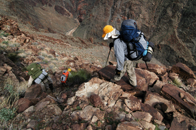
I awoke at 5:00 am on the fifth day and was determined to make this day better than the previous. Everybody has a "bonk" day on a hike of this length and yesterday had been mine. Now, it was time to start feeling stronger as the hike progressed. My breakfasts the first four days had consisted of a bagel with peanut butter, oatmeal and a cup of coffee. Breakfast had felt a little heavy the previous day so, I cut back to 1/2 bagel with peanut butter, oatmeal and coffee. I was packed and ready to go at 6:40 am but the others were operating at a slower pace. They were ready a little after 8:00 am. Chris and I started the hike up and out of Monadnock a few minutes ahead of Dennis and John. The ascent went quickly, with the two of us reaching the Tonto level after 30 minutes of climbing. From here, we continue upstream in a generally southerly direction. We contoured around Emerald Canyon, shortcut a Muav hump into the drainage pouring off the west side of the neck of Scorpion Ridge, and stopped for lunch in a minor drainage off the west pincer of the scorpion.
I also cut back on lunch. I had been eating a bagel with salami and cheese sandwich, crackers with cheese or peanut butter and a snack size Hershey bar with almonds. Today, I reserved the crackers and chocolate bar for dinner. Even in the moderate heat we were experiencing on this hike, the full lunch had felt a little heavy. The lighter fare still provided the necessary calories but left me feeling less bloated during that first hour after eating. We resumed our trek after a 45-minute break, hiking around the tip of the west pincer into Scorpion Bay. It's here that the river has an east-west flow. It took us about an hour to work around a drainage in the bay and reach the tip of the east pincer. Turning this corner, we changed from an easterly to a more northerly track. Our goal for the day had been to get as far as Tuna Creek Canyon. However, it was already 3:30 pm by the time we were hiking along the west rim of the unnamed drainage that empties into Willies Necktie Rapids. At 4:00 pm, we passed the descent route into the drainage that would have shaved some distance to Tuna but would not have shaved any time. And the additional effort required to make a substantial down & up bypass through the drainage was not at all appealing. At 4:30 pm, we spotted several water-filled potholes in a drainage below the east side of Scorpion Ridge. A series of flat pouroff benches at the route level offered plenty of space to layout sleeping bags. The potholes were easily accessible just below the route level so, we decided to stop and setup camp for the night.
We slept beneath the stars that night. I pulled out my mini binocs and scanned the heavens in Gemini, Auriga, Orion, Ursa Major and Cancer. I found the ocassional star cluster or nebula in the winter constellations and detected some bright galaxies in the Great Bear, Ursa Major. Afterwards, I slept well in the warm night air and awoke at 4:30 am to get a head start on the day. We ate breakfast and stowed our gear in the growing morning twilight, hitting the trail at about 6:40 am. Twenty minutes later, we were rounding the head of the Willies Necktie Drainage--there was pothole water here, as well--and by 7:40 am, we had reached the saddle leading into Tuna. Tuna is a major side canyon draining a large area north of the Colorado River. Over the next two hours, we worked our way along the west rim of the canyon to the west arm at the head of Tuna. Here, we found flowing springs with fresh water and stopped to top off our containers. We had developed an efficient system of prefiltering water into a collapsable canteen, pouring off that water into one-liter bottles and using John's steripen to wand the water. The clean water would then be used to fill bladders and other containers.
Freshly resupplied with water, we continued down the west arm and rounded the junction into the east arm of Tuna Creek Canyon. We found a route out of the east arm back up onto the Tonto level and continued south toward Crystal Rapids. Negotiating the drainages and hills along the east side of Tuna would take the better part of the day. We made relatively good progress through the first major drainage. From here, we climbed high above the Tonto and found easy trekking across a Muav shelf into the next relatively minor drainage. The final obstacle was the largest drainage on the east side of Tuna. We passed through there at 1:15 pm and found some shade in which to eat lunch. Afterwards, we made our way out of this drainage and up to the Tonto level. We followed a line between two hills onto a broad plain leading to an overlook of Crystal Rapids. Arriving at the overlook at 3:00 pm, we soon found the cairns marking the descent route through the Tapeats, schist and granite to the river, below.
This descent was hard work on the legs, especially coming at the end of a long day of hiking. It took about an hour of steep and slippery walking to reach the creekbed. Our legs and knees were creaking. while Chris and John continued down stream to the river, Dennis and I luxeriated in the cool, flowing creek. I pulled out my collapsable bucket and repeatedly doused myself with the chill water. It was cleansing and incredibly refreshing. After our 30-minute spa, Dennis and I hiked to the river to join our companions. We found John and Chris enjoying a small pool just above the point where the creek empties into the Colorado. The lull of the rapid roar and the inviting calm of the sandy beach at Crystal Rapids was enough to persuade the four of us to camp here for the night. Soon after our arrival, we spotted a small river party who also pulled in at Crystal. They were a private group made up of Russians, few of whom spoke any English. They took the campsites below the rapids while we took the sites just above the rapids. Through Chris, we had offered to exchange locations--which would have considerably shortened the distance from their rafts to their campsites--but the Russians insisted on taking the camping area below the rapids.
That night, our sixth in the Canyon, we celebrated a bit. Dennis shared a can of oysters and some wheat thins in celebration of having passed the halfway point of the hike. For Dennis, the route we were following would ultimately connect a route for him from Nankoweap to Kanab on the north side of the river. For me, this was just my third trip on a route or trail north of the river, and my first substantially off-trail trek. The following morning, we were off to another early start. Leaving the beach at Crystal Rapids at 6:15, Dennis and I hiked upstream in the creekbed until we found a cairn marking the beginning of the ascent route back up to the Tonto level. The climb lasted about 30 minutes and, taking a break at the rim, we were visited by mosquitoes. Of all the critters I would have expected to encounter on this hike, mosquitoes would not have made the list.
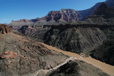
I felt stronger on this, our 7th, day in Grand Canyon. The effort producing the sore muscles and aching joints of the first few days had resulted in better conditioning and improved stamina over the last two days. We continued upstream at the Tonto level, hiking around several major drainages emptying water pouring between the splaid arms emanating from Tower of Ra into the Colorado. By 9:30 am, we were rounding the last branch of the first major drainage. At about 10:30 am, we stopped for a break in a boulder field that was dubbed, Shadehenge, by Chris. By our noon lunch break, we were on the verge of turning the corner around the most southerly arm below Ra. During the afternoon, we hiked across a broad plain to a point overlooking Ninety-four Mile Rapid. While John and I rested in the shade, Dennis and Chris explored a possible descent route to the river. The route would be tricky with packs and, due to the narrowness of several vertical chimneys, lowering packs would be a dicey option. So, at about 3:00 pm we decided to hike upcanyon to an easier descent into Ninety-four Mile. We made good time on this section of Tonto and arrived at the cairned descent route at 3:40 pm. Another 45 minutes of downhill scrambling brought us to the creekbed, which we followed all the way to the river.
That night, we discussed our goal for the next day. There was a realistic shot, we agreed, of reaching Phantom Ranch by nightfall. It would mean a long, long day on the trail, but we expected to find more trails of use as we entered Trinity Canyon and closed in on the Corridor. And we knew there would be a well-etablished trail--with the exception of Piano Alley--all the way from the Cheops/Isis saddle to Bright Angel Campground. This last stretch shouldn't take more than a couple of hours to cover. If we reached Cheops/Isis by 4:00 pm, we would be at Phantom Ranch in time for dinner. Besides, we all were--to borrow Chris's phrase--smelling the barn. Nearly 8 days into a challenging hike, we were all ready for the comforts of home. Little did we realize what awaited us the following morning and that we were destined to spend another night on the lonely Tonto.
Dennis's injury had been unexpected. Even more so, it had been discouraging. Dennis had planned and organized the trip. His desire to complete a route through the Canyon north of the river had been the catalyst that had brought this group together. Of all people, he had earned the right to complete the hike. But in an ironic twist of fate, he was forced to quit the trail. Now, it remained for Chris, John and I to finish what had been started 8 days ago.
The injury and air extraction had delayed us by several hours. So, by the time we were ready to resume the trail, we had already revised our goal downward from the lofty expectation of reaching Phantom Ranch to the more realistic goal of camping on the Tonto above and to the east of Trinity Canyon. We made good time hiking below Tower of Set, crossing the top of a saddle and heading into Trinity Creek at about 3:00 pm. Another 45 minutes of hiking brought us to the cairned descent route into Trinity Creek. It took us a while to determine which was the best route but we found our way down to the creekbed after about 30 minutes of farily easy walking. We rested at a pothole, filtering and treating water for the night and the morning of the following day. Then, we continued downstream to the east arm of Trinity. Rounding that junction, we headed up the east arm to an exit route that had been described to Chris by Doug Nerring. We reached the Tonto level and found an area that was mostly free of cactus in which to setup camp. That night, we ate dinner and watched the lights of Bright Angel Lodge, the Kolb Studio and walkway lights from across the Canyon. We were just a few miles as the raven flies from that place over there. But it seemed a different reality, altogether.
Our ninth and final day on the trail dawned clear and gusty. When we hit the trail it was with a clear focus on our goal of reaching the South Rim by nightfall. The first task was to find a route up into the Muav, where we would continue eastward towards the Cheops/Isis saddle. Between 7:00 am and 9:00 am we followed a series of cairned routes and game tracks across the Muave to the saddle. The major drainage along the southern slopes below Isis Temple proved the biggest obstacle. We were back to our old route-finding ways on that stretch. But our arrival at the saddle connecting Cheops Pyramid to Isis Temple was worth celebrating. We took some photos and admired the truly spectacular view from this narrow bridge between two major Grand Canyon landmarks. Then, it was off to Phantom Ranch. Now, we were hiking on a well-defined and (relatively) heavily used trail. Entering Utah Flats, the obvious track gave way to a faint path and, eventually, to lightly-cairned route. We'd been lulled a bit by the trail down from the saddle and, once we entered Piano Alley, it took us a while to regain the route-finding skills that had served so well during the previous week.
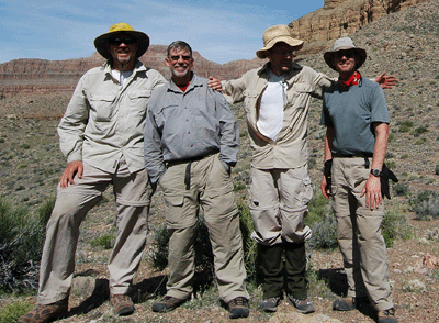
Eventually, we emerged from Piano Alley and found ourselves on the well-worn descent route into Bright Angel Campground. I was first to arrive, setting foot in that northern-most campsite just before noon. We spent the next two hours at the Phantom Ranch Canteen drinking Lemmy's and eating lunch. I purchased a 2009 Phantom Ranch T-shirt and chose some ala carte items from the Canteen lunch box. While packing my gear for the hike to the rim, I stumbled over a loose rock by the Canteen steps and promptly fell on my keister. Angry at having fallen in--of all places--Phantom Ranch, I tossed the rock against the exterior wall of the Canteen in disgust. During lunch, we'd heard the startling kee-rack! of a tree branch being snapped off in the gusting wind. Clouds were moving in from the southwest and, if we wanted to beat the weather, we would need to get started for the rim, soon.
We left Phantom Ranch at 2:00 pm on Sunday, March 22. Pausing only for breaks at Indian Garden and Mile-and-a-Half Resthouse, we arrived at the Bright Angel Trailhead on the South Rim just after 7:00 pm. We kept a steady pace of about 2 miles per hour throughout the long hike out. I felt good; felt strong. The Devil's Corkscrew up through the granite and schist went by quickly. It started to sprinkle on the Corkscrew and, by the time I was hiking up through the Tapeats toward Indian Garden, the light sprinkle had morphed into a steady rain. I stopped just long enough to put on my rain jacket and to wrap my pack in a rain cover. Leaving Indian Garden, we could see the South Rim shrouded by clouds and a regular drizzle continued until we were well beyond the Three Mile Resthouse. The rain abated a bit as we approached the last resthouse. But while we were resting and snacking at Mile-and-a-Half, it started to sleet and snow. The wintery conditions built into a full-blown snow storm during the last half-mile to the rim.
Just before that last long switchback, I passed two young women on the trail. I sensed more than saw that they were following me for a ways. When I turned to see how close they were to me, they were gone. It was then that I felt a burst of energy; a second wind, if you will. My legs moved with a renewed freshness. We'd been on the trail since 6:30 am. It was now approaching 7:00 pm but I was feeling as strong as when we'd just hit the trail. Topping out on the South Rim, I spied Chris's vehicle headlights and made a b-line for it. Soon, my pack and gear were stuffed in the back seat and I was settling into the front passenger seat...setting the seat and back heater to high.
In the days since finishing this hike, I've thought about its significance; what it meant to me. This wasn't the most fun I've ever had in Grand Canyon; not by a long shot. In the end, this was both the most challenging and most rewarding of hikes. I pushed myself physically and mentally to new levels. The long days, and grinding slogs through dense fields and over rough terrain had honed my body to a level of fitness I hadn't enjoyed since before college. But what I'll always treasure from this hike, is the sense that I earned my Grand Canyon veteran stripes. I'm no longer a newbie; no longer wet behind the ears. No, I'm far from being the most experienced of trekkers in this majestic place. But I've met some of her most daunting challenges. And I was up to the test.
Bill Ferris
Flagstaff, Arizona
 |
 |
 |