
 |
 |
|
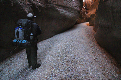
Five minutes into our hike Dennis asked a question that stopped me cold, "So, you brought the stove and fuel, right?." We'd planned to share some supplies. I had agreed to pack a stove and fuel. Dennis had brought pots for cooking. We both packed meals to share, as well. Since Dennis was bringing his cooking pots, I left my Evernew kettle at home. My MSR Pocket Rocket was stowed in that kettle.
"Oh, no. I forgot the stove." I almost couldn't believe what I was saying. Without a stove, we had no way to heat water for our meals. The closest town was Fredonia, a 90-minute drive. Fredonia isn't exactly a metropolis. I don't even think they have a supermarket, let alone a camping supply store. Without the stove, we might have to abort the hike. How could I have been so stupid?
"Well, my stove is back at the truck." Dennis said. And with that and a quick trek to the trailhead to retrieve his Pocket Rocket, we were on our way. It was shortly after 2:00 pm and we had about a three-hour hike to reach the mouth of Hack Canyon where we planned to spend the first night.
Originally, the plan was to spend four days and three nights hiking around Fishtail Mesa. Hiking bud, Dennis Foster, had gotten a permit for that hike in November. But recent winter storms had dumped about two-feet of snow on the north rim of Grand Canyon, enough to shut down forest road access to the trailhead. Anticipating this possibility, we had met for lunch a couple of weeks before the hike to discuss our options. Following that, Dennis had researched some possible routes in western Grand Canyon. The backup plan we settled on was a loop hike down Hack Canyon to Kanab Creek Canyon, up to the Esplanade, around Jumpup Point, downstream through Jumpup Canyon to Kanab Creek Canyon and up Kanab to Hack. This would end up being one of the most enjoyable Grand Canyon hikes I've done.

Hack Canyon is used as pasture land by local ranchers. It is accessible via a well-maintained dirt road that terminates near Willow spring. The trailhead is in the middle of a wide open canyon bounded by layers of Kaibab, Toroweap and Coconino on both sides. A fence keeps the cattle from wandering too far up-canyon. Since Hack and Kanab Creek both support small cattle herds, they have well-developed animal trails that are particularly helpful through the rockiest sections of creekbed. While hiking downstream in Hack that first day, we passed a couple of makeshift corrals and cowboy camps. The creek decends through about 500-feet of Supai before reaching the junction with Kanab Creek. It was 5:00 pm when we decided to setup camp at a well-used site near the mouth of Hack.
We setup our tents beneath a rocky overhang and then went about the process of preparing dinner. Since we were camping in a National Wilderness area, there was no prohibition against a fire. A good fire always lifts my spirits and, to my thinking, is the perfect way to end to a day on the trail. So after dinner, we built a small fire and chatted for a while. Darkness comes early to Grand Canyon this time of year. So, despite enjoying the fire for an hour-and-a-half, it was only about 7:30 pm when we turned in for the night. And a cold night it turned out to be. The thermometer in Dennis' tent dropped to 34 degrees. I don't carry a thermometer on backpacks but didn't need one to know how crisp it was. When we awoke on Sunday, the sun was up but our camp was still cloaked in shadow. The canyon walls saw to that.
It was shortly after 10:30 am when we finally broke camp to begin our first full day on the trail. Job one was to find the trail from Kanab Creek bed up to the Esplanade. The Esplanade is found throughout western Grand Canyon at the level of the Supai formation, between the Coconino and the Redwall. If you're not familiar with this formation, it's an open and generally flat slickstone surface punctuated by some amazing rock formations. If you've seen the movie, "Planet of the Apes," (the original, not the remake) then you've seen the Esplanade. It's the alien environment into which Taylor (Charleton Heston) and his crewmates crashland at the beginning of the film. With its caramel hue and bizzare formations, the Esplanade presents a decidedly otherworldly appearance.

We reached the junction of Hack and Kanab in just five minutes and, soon thereafter, had found the cairn marking the beginning of the Lawson-Hack trail. Built for horse travel, this trail ascends gradually through the canyon wall. Its gentle slope and smooth tread made for some of the easiest hiking I've known in Grand Canyon. We topped out on the Esplanade at 11:25 am and took a short break. After changing out of my long johns and shedding a winter jacket, I explored some nearby rock formations while Dennis reviewed some trail guides. According to the guides, the Lawson-Hack trail should intersect the Ranger Trail (#41) which, in turn, would take us around Jumpup Point. Having gotten a late start, we decided to hike a couple more hours before breaking for lunch. It was noon when we resumed the trail.
I use that term, loosely. There was no trail, per se, through this slickstone environ. But there were an abundance of large cairns that made staying on route a breeze. We arrived at the junction with the Ranger Trail at 12:40 pm and headed south for Jumpup Point. Sections of trail that remained cloaked in shade throughout the day were hard and unyielding. Sections warmed by the sun were softer and, in some places, even muddy. We saw abundant evidence of animal use of the trail. One of the more common prints showed four pads, no claws and appeared to be about two inches across.
At 1:45 pm, we stopped for lunch on a slick rock outcrop overlooking the Esplanade. The view was quite striking. Recent winter storms had replenished water pockets throughout the Esplanade. Their ubiquitous, glistening presence assuaged any concerns we had about running short on water during this hike. I ate my usual bagel with cheese & salami sandwich--the same lunch every day of the trip. Dennis likes variety and, on this day, he'd packed a special treat; a fresh avocado. He shared half of it with me and I can honestly say that was one of the best avocados I've ever eaten.
After lunch, we continued on the Ranger trail around the southern tip of Jumpup Point and were rewarded for the effort with an expansive view of western Grand Canyon. It was a view that included Kanab and Chickapanagi points to the south and, to the south and east, Fishtail Mesa. The north-facing slopes of Fishtail were snow-covered and darkened by a constant shade. The notch between Indian Hollow and Fishtail looked bitterly cold and I quietly thanked our good fortune at having to opt for the backup hike.
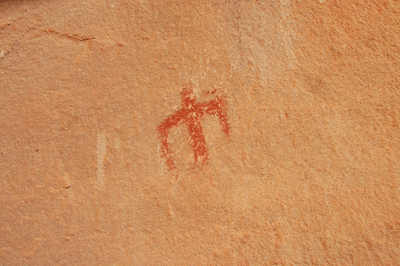
By 3:30 pm, we had turned the southwest corner of Jumpup and were heading around to the east side of the mesa. I was hiking a few paces ahead of Dennis when I heard him call, "Hey Bill, come check this out."
Doubling back, I saw what had captured Dennis' attention. He had found a series of pictographs in a rock formation. The pictographs were a rusty red color and depicted stick figure people. Some figures appeared to be wearing feathers and one pictograph included an animal. One of the last figures in the series had been scratched into the rock. It looked like a deer or antelope and, being the only etched figure, we both questioned its authenticity as the work of an Ancestral Puebloan.
Continuing the hike, we discussed our options. Our goal had been to work around the east side of Jumpup to a route down a canyon to lower Jumpup Spring. With only a few hours of daylight remaining, we accepted the fact that we couldn't reach the spring before dark. However, that turned out not to be a problem as there was an abundance of freshly refilled water pockets along the trail. At 4:30 pm, the trail passed through an area of slick rock with numerous deep potholes. All were filled with fresh water. Just a bit further down trail, there was a large flat area where we could setup tents. So, we decided to call it a day and setup camp. After pitching our tents, we walked back to one of the deeper potholes, broke through the ice, and filtered enough water for dinner and breakfast the following morning.
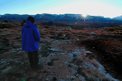
As mentioned previously, we shared meals at dinner. I had packed a two-serving packet of dehydrated beef chili mac, which we ate the first night. For our third and last night of the hike, I'd chosen spaghetti and lasagna as options. For the second night's victuals, Dennis prepared Vietnamese noodles and chicken. I contributed a dehydrated mocha mousse pie dessert that turned out to be a total disaster. Who wants a cold dessert on a freezing night without a fire? Well, at least it was chocolate. Hot or cold, chocolate always tastes good. Since we were camped on slick rock, there was a noted absence of available firewood. And without wood, there would be no campfire. With dinner complete and a chill winter's night falling, we retreated to the warming comfort of our tents at the advanced hour of 6:30 pm.
The second morning dawned clear and crisp. It was 7:00 am when I unzipped my Big Agnes mummy bag. I'd awoken a few hours before to answer nature's call. While outside the tent, I'd paused to drink in the winter Milky Way. Orion, Auriga, Taurus, Gemini and other seasonal constellations decorated the sky. The view was almost enough to justify packing a small telescope for the hike. But it was 3:00 am, extremely cold and my sleeping back offered warmth. So, back I crawled for a few more hours sleep. Unlike the first campsite which was still in shade as late as 10:30 am, our spot on the Esplanade caught the first rays of the rising sun at 8:20 am. It's amazing how warm 40 degrees can feel in comparison to the 30 degrees that greeted you just two hours before. After a breakfast of scrambled eggs, bagel with peanut butter and coffee, I took my time striking camp. The sun felt good. After packing, I did some exploring of the rock formations above our campsite.
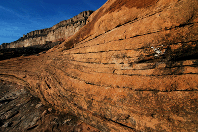
The Esplanade offers a potpourri of sights to stimulate the senses. The photos I take on most hikes feature broad landscapes. But on this trip, my eye was drawn time and again to the aesthetics of nearby slick rock architecture. The lines, curves and hues offer wonderful possibilities of composition. Sometimes, the shape of a rock would catch my eye. At others, lines or shadows captured the imagination. One could spend countless days exploring the interplay between light and stone on the Esplanade. But we had trail to hike and places to see. So all too soon, I was back in camp to stow the last few items. We resumed the trail at 10:45 am.
We didn't know exactly where the trail into Jumpup Canyon would depart the Esplanade. We had no map showing the junction and no precise notes from earlier hikes. Dennis had found reports seeming to indicate that the intersection might be clearly marked. There might even be a sign as there had been at the meeting of the Lawson-Hack trail with the Ranger trail. We passed through two drainages where I thought we might find the trail. But after 45 minutes on the trail, it was becoming clear that we would not intersect the route to Jumpup Spring until the last possible drainage. An hour into this day's hike we came to a fence line that began at the trail and continued upslope to the northwest. Across from the fence post, I spotted the faint outline of a trail descending into a drainage. It was neither cairned nor signed but, being a trail, we decided to take it.
The trail actually became more obvious the further we descended into the drainage. Soon enough, we were in the creek bed and heading downstream. We passed through an area with large Cottonwood trees. Beneath the trees, the ground was flat and soft with leaves. There was abundant evidence that the area had been used as a campsite, including a stone fire ring. There was a constant water flow through the canyon, one that occassionally formed small falls while splashing over rocks and boulders. Shortly after 12:00 pm, we stopped at a sunny spot to drop our packs. We continued downstream to look for a 10-foot waterfall Dennis had read about and the bypass that one hiker had described as, "a makeshift ladder." Just five minutes from where we'd dropped the packs, Dennis and I got to the falls. They're in a narrow section of Jumpup with no obvious descent route to bypass the obstacle. However, following the cliff along the left (east) side brought us to a shelf from which we could see the route to the floor below.

The shelf formed an L-shaped outcropping from the cliff. We could see stone pillars that formed narrow steps along the cliff face. These steps led down about ten feet from the shelf. At the base of the last stone step, a log and rope ladder descended another eight feet to the angled top of a large slab of limestone. After descending this slab, there was a small level area at the base of the 25-foot cliff. From there, one could angle around to another boulder with a sloping face that covered the last 15 feet or so to the canyon floor. I went first, leaving my pack at the top and carefully descending the stone steps to the ladder. The ladder was old but firm and strong. It easily took my weight. Before Dennis made his way down the ladder, he used ropes to lower our packs to where I stood at the base of the cliff. Then he negotiated the bypass as I had done, minutes before. After reaching my level, Dennis was first to slide down the boulder face to the canyon floor. I lowered our packs to him, before sliding down myself. All told, it had taken about an hour to scout the route, plan our approach, return for the packs and make the descent. This was one of the big highlights of the hike.
A few minutes downstream from the makeshift ladder, we found a rock shelf in the sun where we stopped for lunch. I headed back upstream to check out the waterfall and snap some photos. While I was at the falls, Dennis filtered a couple of bottles of water from Lower Jumpup Spring. We ate lunch and resumed our trek through Lower Jumpup shortly after 2:00 pm. It took an hour to reach the junction with Sowats Canyon. Near this junction, we walked across a huge slab of exposed Redwall limestone. The rock had its natural light gray hue; not the stained, rusty red found in most areas of the canyon. Soon after the junction with Sowats, Jumpup Canyon begins its descent through the Redwall. This section, the Redwall Narrows, was truly spectacular. The vertical walls confined the creek bed to less than ten feet in width in places. Little direct sunlight touched this narrow slot and the light had a ghostly blue tone. When we passed the junction with Indian Hollow Canyon at 3:45 pm, the narrowness of the opening offered little clue as to the extent of the canyon that lay beyond.
At some point during this stretch, I realized I had forgotten my leather gloves during our short break at the junction with Sowats and Jumpup. I could have doubled back to look for the gloves, but that would have taken 90 minutes or more. The lateness of the day and the fact that I still had a pair of thin winter gloves made the decision relatively easy to leave my leather gloves as a trophy for some future hiker. The sights in Lower Jumpup included areas where large icicles had formed from the steady, slow drip of seeps and snow melt down the canyon walls. In some places, large overhangs sheltered verdant zones where trees, cactus and other shrubs grew in sandy deposits along the wall of the canyon. At 4:25 pm, we passed a muddy, stinky pool of water that Dennis recalled as "Frog Pond Hollow" from an earlier hike.
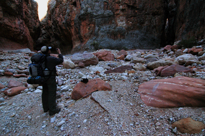
Knowing we had less than two hours of daylight remaining, Dennis and I discussed our options. Our goal had been to reach the junction with Kanab Creek Canyon and find a camping spot there. However, not wanting to setup camp in the dark, we started keeping an eye open for a suitable location to pitch a couple of tents in Lower Jumpup. Shortly after 5:00 pm, we arrived at just such a location. A huge shelf extended from the east wall of the canyon, rising six-to-eight feet above the canyon floor. The west wall of the canyon had been carved away and hollowed such that it formed a huge overhand sheltering much of the shelf. In fact, the constant dripping of snow melt painted the sandy soil in places. We found an area on the shelf where we could setup our tents and set up camp for the night.
And an interesting night it turned out to be. It was warmer in Jumpup Canyon than it had been at either of our first two camp sites. So after dinner, we sat and chatted until 8:00 pm. Our voices echoed off the nearby canyon walls as did the hoot of an owl and the sounds of rocks knocking about on the canyon floor. The origin of the rock crashing sound remained a mystery until the following morning. I slept comfortably in just my long johns through most of the night. It wasn't until a 1:00 am answer to nature's call that I put on my sweater and winter cap for additional warmth.
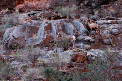
I awoke at 6:35 am. This was to be our fourth and last day of the hike. We had to cover a lot of ground, including a hike to the junction with Kanab Creek, continuing upstream through winding Kanab to the mouth of Hack Canyon, and trekking up through Hack to the trailhead where Dennis' truck was parked. We left our Jumpup Canyon campsite--my favorite of the trip--at 8:50 am. After barely ten minutes, we arrived at Kanab. While taking in the view, Dennis noticed three bighorn sheep grazing on grass atop the delta on the opposite side of the canyon. The largest ram was clearly the leader. One of the two smaller sheep was wearing what appeared to be a collar, perhaps with a transmitter. I managed to get a bit closer, close enough to grab a decent shot with the D70. But as skidish as bighorn are, they didn't hang around too long for this photo op. As they scampered downstream, the sheep scattered rocks in their wake. And the clattering echoing off the walls of the canyon sounded suspiciously like the sounds we'd wondered about the previous night.
Our maps showed Kanab Creek following a winding, circuitous route through the canyon. There were five squares on the map between the junction with Jumpup and the mouth of Hack. But with all the curves and bends, I estimated at least eight miles of hiking lay ahead before we would arrive at Hack Canyon. With all the bends in the creek, it was a challenge to get oriented as to our exact location. And while some portions of the creek offered relatively easy hiking, others were populated by large, icy water deposits or chunky boulders that made good footing hard to find. The next eight miles looked like they would be slow going. But that was about to change.
As we made our way upstream, we began to follow the animal trails on the shelves of sedimentary deposits edging the more elaborate bends in the creek. The trails were narrow but well-defined. They made for much easier hiking than that offered in the creek bed. These trails also offered a more direct route up bendy Kanab. Time passed quickly as well as landmarks. Ninety minutes up from Jumpup, we passed an unnamed side canyon on our left. That was at 10:37 am. Another hour of hiking brought us to a minor drainage on our right. And at 11:48 am, we arrived at expansive Chamberlain Canyon.
The delta at the mouth of Chamberlain is expansive. Fortunately, we found a cattle trail that led us more directly across this wide open shelf. Thirty minutes of solid hiking at a good pace brought us, eventually, to the upstream side of the delta. Along the way, we found signs of past use by cowboys and cattle. These included makeshift corrals, a discarded shovel blade and, of course, cattle and horse tracks in the trail. The circuitous route through Kanab Creek meant that we were alternately hiking in sun and shade. In the shade, the trail was hard and unyielding. Grassy fields were blanketed by a wintry frost. In the sun, the trail was either soft or muddy, which made for occassionally slippery footing. As we made our way upstream through Kanab, the Redwall limestone walls on either side of the creek bed grew gradually shorter. About two miles downstream from Hack, the Redwall disappeared altogether.
We broke for lunch at 12:45 pm, stopping in a minor side canyon on our right. The side canyon drained from the Esplanade below Jumpup Point into Kanab Creek. It was a sunny spot that offered our last extended break of the day. This lunch break lasted just 40 minutes. We were about two miles below the mouth of Hack Canyon, which meant we still had some ten miles (4 to 5 hours) to hike to reach the truck. It was 1:25 when we resumed trail and, at 2:00 pm, we arrived at the cairned trail at the mouth of Hack Canyon. Being a bit concerned about my water situation, I decided to filter some water from a nearby pool. We also had to stop at our first night's camp site to retrieve the trash cache we'd left. With those chores completed, we began the final leg of our hike. It was 2:40 pm when we departed the cowboy camp for the trailhead. Following cattle trails through most of Hack allowed us to maintain a brisk pace. We covered the approximately six miles in just under 2 1/2 hours, arriving at the trailhead at 5:03 pm.
Highlights from this hike included the spectacular views while travelling through the Esplanade, negotiating the bypass of the falls in Jumpup, making our way through the Redwall Narrows, our last night's camp site in Lower Jumpup and the encounter with the bighorn in Kanab. The hiking was about as easy as I've encountered in Grand Canyon. Recent winter storms had resupplied springs and potholes, making water readily available throughout. And, despite the chilly winter nights, abundant sun during the day kept our bodies warm and spirits high. This is definitely a hike I recommend for any moderately experienced Grand Canyon hiker.
Bill Ferris
Flagstaff, Arizona
 |
 |
 |