 |
 |
|

"DO NOT attempt to hike from the rim to the river and back in one day, especially during the months of May to September." - Grand Canyon National Park
This warning is posted at the South Kaibab trailhead for one simple reason: people have died attempting to hike to the river and back in a single day. In their book, Over the Edge: Death in Grand Canyon, Michael Ghiglieri and Thomas Myers attribute 65 deaths in Grand Canyon to environmental factors. Heat stroke was the culprit in 30 of those 65 deaths and heat was at least a contributing factor in many others. During the five-month period from May to September when most of the nearly five million tourists who annually visit Grand Canyon are roaming the rim trails, many do so unaware that the comfortable conditions at Mather Pont yield to extreme desert heat along the Colorado River. Phantom Ranch routinely hits 100 degrees during the summer months and daytime highs in the 110+ range are not uncommon. In an environment where lethal heat combines with desert dryness, novice hikers can quickly find themselves in serious trouble if they venture too far with too little water.
Knowing this, you might think I would have hesitated before accepting hiking bud, Dennis Foster's, invitation to do a rim-to-river hike in July. It would be hot at the river; 107 at Phantom Ranch, according to the National Weather Service forecast. We would be taking the South Kaibab trail down and back, and there is no water along the South Kaibab. And this would be my first time hiking to the river and back in a day. These were all good reasons to think long and hard before committing to the hike. But I didn't hesitate. I immediately replied with an enthusiastic, "I'm in!" I did so because the obvious risk factors were countered by the fact that I would be with two very experienced Grand Canyon hikers, Dennis and his long-time hiking partner John Eastwood. Also, the plan that Dennis had outlined sounded reasonable.
The plan was simple: we would get an early start, arrive at the river well before noon, recover at the Phantom Ranch cantina, and be on our way back to the rim before the full heat of the day set in. We would return via the South Kaibab trail--the shortest, fastest route from river to rim--and every step we took would be a step away from the heat of the inner canyon. Also, despite the greater exposure to the sun along South Kaibab, there are strategically located places that offer reliable shade and we planned to take full advantage of that on the return hike. Despite the obvious risks of doing this hike in mid-July, I felt confident that we had the experience and knowledge to do the hike.

Dennis arrived at my house at 4:05 am. After transferring his gear to my Isuzu Rodeo, we headed out to pick up Eastwood and soon the three of us were on our way to Grand Canyon. Highway 180 heads northwest from Flagstaff to Hwy. 64, the junction located at the little town of Valle. It's about a 50 mile drive through the Ponderosa pines of the Coconino National Forest and the pinon & juniper woodlands of the Kaibab National Forest. About ten miles outside Valle, we started to see elk grazing by the roadside. They were difficult to see in the early morning twilight. Suddenly, between six and ten elk decided to cross Hwy. 180 at very moment we were passing. Dennis was the first to see them, "Lookout!" They were close, which didn't afford much time to react, and the spacing between the great animals seemed enough to allow us safe passage through the small herd. So, I decided that the safest response was to keep the pedal to the metal. We zipped through a large gap in the herd and didn't look back. If we'd arrived a few seconds later, we would have had a high speed encounter with a 500 to 600 pound animal. But we weren't, we didn't and we kept moving, arriving at the south entrance to Grand Canyon shortly after 6:00 am.
We continued to the picnic area just east of the road to Yaki Point, grabbed our gear and hoofed it through the forest to the trailhead. There, we encountered a small party of hikers making ready to depart. One of them was kind enough to take a group photo of us with Dennis' camera. At 6:40 am, we took our first steps down the South Kaibab and were on our way to Phantom Ranch. The sky was clear and the temperature was perfect; a condition that would change significantly over the course of the next few hours. John set a good pace and it didn't take long until we reached Ooh Ahh Point. The view of the canyon bathed in early morning light was simply stunning. So, while John and Dennis pressed on, I stopped to take some pictures. But soon, I'd caught up with my companions and we trooped into the Cedar Ridge rest area at 7:10 am. Thirty minutes had elapsed since leaving the South Rim trailhead.
Leaving Cedar Ridge, we traversed the Supai below O'Neill Butte. In many places, the trail was topped by a thin layer of fine, red dust. At times, this silty carpet conjured images of moon dust. Another 30-minutes elapsed before we made it to the brink of the descent through the Redwall. It was here that we made our first water cache for the return trip. John and Dennis each left one liter bottles in our little depression in the rocks. I cached two 750 ml bottles of (mostly) frozen water. From this vantage point atop the Redwall, we could see the place where the Old Miner's route departed the Tonto, winding its way through the Tapeats and schist down to the river trail. We took a short break for some snacks and water. By 8:00 am, we began our descent through the Redwall.
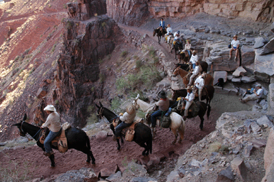
Just ten minutes into this switchbacking descent, we stopped in some shade to allow a mule pack train to pass. Another group of five hikers were kind enough to share this spot, which offered a welcome respite from the morning heat. Below us, another group of four backpackers had already passed the mules and were continuing their trek toward Phantom Ranch. Above, three day hikers waited for the same pack train to pass. It was a small train--four mules plus the wrangler--and, after a few minutes, we resumed the trail. At the foot of this 500-foot descent, we emerged into the Muav limestone and traversed below the Natural Arch. This section of trail drops another 500 feet en route to the junction with the Tonto Trail.

The Tipoff begins the descent through the Tapeats and kicks off the final leg of the South Kaibab's journey to the Colorado. This descent drops 1,700 feet to the river over the course of 1.7 miles. This section of trail leads into the inner gorge of Grand Canyon, where the heat literally radiates from the dark walls of Vishnu schist lining this region of the canyon. It was during the upper portion of this descent that I remarked to Dennis, "It feels like somebody set the oven on low." The heat and direct exposure to the sun were draining, which made it all the more a relief to arrive at Big Shady.
Big Shady lies just below the Tipoff at a bend in the trail that is shielded from the sun's harsh glare by a vertical wall of sandstone. This spot is reliably shady throughout the day and offers a welcome respite from the summer heat. The pile of rusted old cans on an elevated shelf beside the trail gives testimony to the fact that Big Shady has been known to the locals for many years. While here, no fewer than four mule trains paused for a rest while en route from Phantom Ranch to the rim. The first was a pack train. Next, was two groups of Phantom Ranch guests forming a single, long string. Another pack train brought up the rear. It had taken us about 40 minutes to reach Big Shady from the top of the Redwall. After a 20-minute break, we cached more water for the return hike before hitting the trail for the final push to the river. It was about 9:00 am when we departed Big Shady.
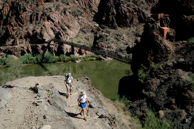
If the upper section of the final descent felt like an oven set to low, the lower portion felt like an oven set to warm. The energy-sapping heat oozed from the dark walls of schist lining the inner gorge. As we dropped closer to the river, the Colorado presented an interesting mix of clear, green water with undercurrents of chocolate silt. The off mixture reminded me of a not-quite-mixed oil and vinegar dressing. At 9:40 am, John and Dennis entered the tunnel to the Kaibab suspension bridge. I had hung back to capture the moment with my Nikon and jogged ahead to catch up with the guys on the bridge. The baking temperatures along the river trail and through the lower sections of Phantom Ranch were enough to bring on a serious thirst. When we arrived at the cantina at 9:50 am, all three of us were ready for a big, icy cup of Lemmy.
We spent most of our nearly two-hour break at Phantom Ranch in the air-conditioned comfort of the cantina. Drinking lemonade, writing post cards and eating lunch were the main tasks at hand. The last order of business was to refill our water bladders and bottles. These were topped of with ice purchased in the cantina ($1.50 per bag). Finally, before heading down to the creek, I removed my hat and shirt, and gave them a thorough soaking at the spigot outside the cantina. Feeling refreshed and cooler, we trekked down trail to a shady spot by Bright Angel Creek where we could sit in the cool water and soak feet made tired by the morning's hike. By the time our boots were laced and we were heading for the Kaibab suspension bridge, it was nearly 12:00 pm and the hottest part of the day lay ahead.
The initial ascent to the Tipoff is the longest, steepest section of the South Kaibab. This would also be the hottest part of the return hike to the rim. By now, the oven was set to bake and we definitely paid a price for choosing to hike the inner gorge at midday in July. Fortunately, there were three strategically-located shady spots along the climb that allowed us to take short breaks from the baking sun during the climb. When we arrived at Big Shady about one hour after leaving the river, we were ready for an extended break. And Dennis had just the treat to renew our enthusiasm for the hike. He had packed an insulated lunch bag with dry ice, Häagen Dazs mini's and sodas. It was an amazing, unexpected treat that raised our spirits for the hike to come.
We savored the ice cream and cold drinks, refilled our bladders with the cached water and napped. Two people passed us on the way down to Bright Angel campground. Otherwise, we wouldn't see any other hikers until Cedar Ridge, much later in the day. After a solid two-hour break, we pushed onward and upward to the Tonto platform. It was 2:50 pm when we left Big Shady. Over the next hour, we made slow but steady progress through the Muav to the base of the Redwall ascent. Finding a shady spot, we stopped for a much-needed rest before beginning the slog up the switchbacks through the Redwall. Some sections of this stretch were in the shade but it was mostly exposed to the late afternoon sun. I was thoroughly exhausted by the time we arrived at our final water cache. We rested in the shade for 15-20 minutes, refilling our water bladders, snacking and preparing ourselves for push to Cedar Ridge.
The traverse below O'Neill Butte runs along the eastern flank, which kept us in the shade and refreshed by a late afternoon breeze for much of that section of trail. By now, we were above the debilitating inner canyon heat but we were also tired, dehydrated and hungry. It was after 5:00 pm and we'd been on the trail nearly eleven hours. Ascending through the Redwall, my lower back had started aching and my stomach started feeling a bit unsettled. I'd been nursing a Gookinaid mixture in my water bladder, all day. However, despite the five liters of Gookinaid I'd consumed, my body was dehydrated and starving for energy. I had two liters of water for the climb to the rim and plenty of snacks. So, regardless of what my stomach was saying, I made it a point to snack at every stop we made between Cedar Ridge and the trailhead.

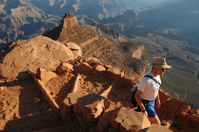
We arrived at the Cedar Ridge rest area about 6:15 pm and ended up resting there for 30 minutes. We met several day hikers who'd made the trek down from the rim in the cool, early evening air. It was reassuring to look up and see the switchbacks marking the final ascent to the South Kaibab trailhead. Victory was within sight. Now, it was just a matter of putting one foot in front to the other until we reached our goal. During that final climb to the rim, I took another break at Ooh Ahh Point. By the time I'd reached the base of the final ascent, the golden hour had arrived. The last rays of day painted the canyon a spectacular golden hue. The colors were simply amazing so, I unpacked the Nikon and snapped several exposures during the final climb. At the rim, I took one last shot of Dennis and John. The look tired but satisfied in that shot. We'd finished our round-trip day hike to the river and were more than ready to head home.
In hindsight, I believe our planning and execution were reasonably sound. Arriving at the canyon at 6:00 am allowed us to make the initial descent to the river before the full heat of the day overwhelmed the canyon. Caching water along the descent allowed us to reduce our pack weight, which certainly paid off on the climb to the South Rim. Waiting until later in the day to begin the return hike would have meant spending another three or four energy-sapping hours at the canyon bottom. Unless we'd waited until sunset to make begin the return trip, it wouldn't have been any cooler on the first leg up through the schist. As it was, we suffered for an hour on that first leg but were rewarded with Big Shady, a rest area 1,600 feet nearer the rim. And by the time we reached Cedar Ridge, the draining summer heat had begun to break, the sun had move far enough to the west to put much of the traverse below O'Neill Butte in the shade and the developing monsoon clouds provided shade along the trail from Cedar Ridge to the rim. It was a challenging but rewarding hike in Grand Canyon; one I hope to do again...but not in July.
Bill Ferris
Flagstaff, Arizona
 |
 |
 |