
 |
 |
|
I don't recall the exact time of day or where exactly I was on the Grandview Trail. What I do recall, is that it was dark and I was puking. I was suffering from heat exhaustion in the Grand Canyon. Talk about the perfect end to a perfect day.
After purging the contents of my stomach, I actually felt better and, within a few minutes, felt ready to resume the hike to the rim. I was with friend and hiking partner, Dennis Foster. (See Dennis' blog entry) We were somewhere in the middle of the ascent through the Coconino formation and maybe 3/4 mile from the trailhead. Normally, this section of trail wouldn't require more than 20-30 minutes to get through. But on this night in the condition I was in, it probably took an hour or more.
The day had begun, well enough. It was about 5:15 am when Dennis and I met at Park Santa Fe on the east side of Flagstaff. After transferring my gear to Dennis' truck, we were off. We drove north on Highway 89 past Sunset Crater National Monument to Cameron, where we stopped at a gas station so I could get a breakfast burrito. From Cameron, we turned west on Highway 64 and continued to the eastern entrance to Grand Canyon. We took the rim drive to Grandview Point and, by the time we took our first steps down the trail, it was about 7:15 am.
Our plan was to take the Grandview trail to Horseshoe Mesa, descend the east side route past Pete Berry's copper mine to Miners Spring, follow the Tonto Trail to an overlook of the Colorado, lunch and rest, then return via a route up through a break in the Redwall within the west fork of the Horseshoe. Along the way, Dennis wanted to look for a large cairn marking a route leading below the Tapeats near our planned lunch stop. And the weather could hardly have been better for a late-July hike in Grand Canyon. High temperatures for the day were predicted to reach the mid-to-upper 70's on the South Rim. That translates to highs in the upper 80's to low 90's on the Tonto platform. Arizona's summer monsoon had been running full tilt the last two weeks, which meant cloud cover would build throughout the day, providing a welcome respite from direct glare of the midday sun.
I had what I thought would be plenty of water. I started the day with three liters in my Camelbak bladder, another two liters of frozen water in my pack that I planned to cache along the Grandview for our return ascent, and 1 1/2 liters of Gookinaid mixture in bottles in the side pockets of my daypack. In hindsight, I could have brought my Katedyn water filter and topped off the Camelbak at Miners Spring. I was probably a liter down at that point in the hike. Would another liter have prevented or mitigated the heat exhaustion? I don't know; but it would not have worsened the situation. Having more water is never a bad thing in Grand Canyon in July.
The hike from the trailhead to Horseshoe Mesa went well enough. We arrived at the upper water cache point--the saddle below the Coconino overlooking Cottonwood Creek--after 45 minutes on the trail. Along the way, we encountered a father and son from Alabama who were "hiking to the river" on the Grandview without any water. We explained that the Grandview trail doesn't go all the way to the river and that anyone hiking below the rim in Grand Canyon in July without water is asking for serious trouble. Then, we strongly advised them to turn around and return to the top. We suggested they head west to the South Kaibab or (even better) the Bright Angel Trail, which offer short day hikes suitable for first-time visitors. And most important, we suggested they buy some water before hiking any more trails in the canyon. By the end of my day in Grand Canyon, the irony of that chance encounter was emblazoned in my mind.
After a short break at the saddle, we continued along the Grandview, descending its cobblestoned trail and arriving at our lower water cache just above Horseshoe Mesa after 45 minutes. We'd been in the canyon nearly two hours. The Grandview Trail had been in the shade until the last 1/4 mile or so but it was humid. During the hike from the saddle to Horseshoe Mesa, I was sweating far more than I would have expected given the shade and moderate temperatures. But the humidity was palpable. In hindsight, this may have been the beginning of my decline towards heat exhaustion. Still, having deposited two liters of water, my pack weight was down by 4.3 pounds and I was feeling quite fresh for the descent to Pete Berry's copper mine and Miners Spring.
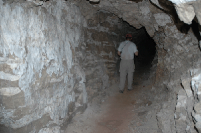
It was 9:15 am when we started downt the east side of Horseshoe Mesa. Fifteen minutes later we were dropping our packs just inside the mine entrance and retrieving headlamps for the investigation. We spent about 30 minutes exploring the main shaft and several short branches. The walls and ceiling were regularly splotched by blue copper and white crystalline deposits. One of the more interesting finds was a pit at the end of one shaft where miscellaneous pipes and other materials lay strewn. With my relatively weak headlamp, I was unable to see to the bottom of this hole. Berry's rail system still lay upon the floor of the main shaft. This presumably leads to one of the last ore deposit he worked in this mine.
The interior of the mine was much cooler than the outside air and, by the time we emerged into the late-morning sun, I felt refreshed and ready for the next stage of our hike. This would be a short descent to Miners Spring. We were back on the trail about 10:05 am and arrived at the Miners Spring trail some 15 minutes later. This trail led to a wonderful shady area where we removed our boots, snacked and rested before the push to the Sockdolager overlook. The Miners Spring collection pool is carpeted with some kind of greenish growth. It's enough to give the well-hydrated hiker pause but probably appears as manna from heaven to the hiker at the end of a long day on the trail. The spring that feeds this shallow pool with its steady drip seems clean enough.
After the break at Miners Spring, we began what would be our only leg of the hike during which we were exposed, throughout, to the constant beating of the sun. It was 11:00 am when we resumed the trail and, over the next 90 minutes or so, we covered 2 3/4 miles from Miners Spring to the Sockdolager overlook at the edge of the Tonto platform. We were in the sun and it was hot but not so bad that I worried about any ill effects. Along the way, we spooked a mule deer but she skipped upward through the Muav to a shelf high above the trail. Having reached safety, she seemed to pause and look right at me before casually trotting out of view beyond the ledge.
The hike along the Tonto below the eastern fork of Horseshoe Mesa provides some enticing views into Hance Creek canyon. At various places, there are clumps of trees where rainwater washes down from above or a spring feeds the comparatively lush vegetation of these small oases. Dennis also pointed out an obvious, well-worn route through the Tapeats and into Hance Creek canyon. We didn't have time to stop and explore but there appears to be a route from Hance Creek to the eastern slopes of Horseshoe Mesas that would cut significant distance, if not time, from the more established Tonto Trail.
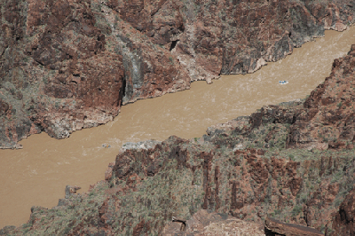
Arriving at the Sockdolager Rapids overlook, we found a patch of shade below the rim and settled in for lunch and a midday break. It was a 2 1/2 hour siesta, during which we used our binoculars to scan the landscape on the other side of the Colorado. Dennis pointed out several tailing flows--light colored, rocky debris streams--emanating from John Hance's asbestos mines. He also mentioned that there is supposed to be a large cairn along the edge of the Tonto platform marking the location of Hance's mines. Soon after, I spotted a small, dark "block" across the canyon at the edge of the Tonto. Raising my binoculars, this block presented a symmetrical shape. Is this Hance's cairn? See my pictures from this hike and decide for yourself.
Just after lunch, we noticed rafts resting on an upstream beach. This was a river trip stopped for lunch. About 20 minutes later, the first of three rafts left the beach and headed downstream to Sockdolager Rapids. Over the next 20 minutes or so, we watched as all three rafts rode the Sockdolager maelstrom. It was an interesting perspective, especially compared to the sights I'd seen just two months earlier while camped at Granite Rapids. (See my Hermit Loop report) There, the rafts rode the rapids within a stone's throw of where I was standing along the Colorado River. Watching these rafts in Sockdolager was something akin to watching a silent movie. And later, Dennis and I wondered how often hikers have watched river parties going through these rapids. There is no easy trail to this part of the river so, it can't be too common a sight.
It was about 1:30 pm when the last raft departed from view. The hottest part of the day was upon us so we decided to stay in the shade and nap until about 3:00 pm before resuming the hike. Stretching out on the rocks, they felt hot through my shirt and pants. They'd been exposed to the morning sun and were now radiating the heat they'd stored during those early hours of the day. After awhile, I grew used to the warmth and managed to take a short nap. Looking back, I wonder what contribution the warm rocks made to my deterioration into heat exhaustion? Dennis, being the smart and experienced hiker he is, brings a plastic sheet and a tattered piece of foam pad on his hikes. I'd looked at the padding as something of an extravagance. But in hindsight, I wonder if it also provided him some insulation against the heat in those rocks. I may look for something similar to add to my equipment list.
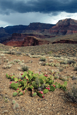
Storm clouds built throughout the afternoon and, by the time we left the Sockdolager overlook, the gray sky diluted the intensity of the mid afternoon sun. It made the hiking easier as we headed west to check out a stone cairn Dennis had visited twice before on hikes below Horseshoe Mesa. The cairn, which was visible from the route to the overlook, marks a trail that leads below the Tapeats. It's a large cairn, probably four-feet high and three-feet across. Eventually, we made our way back to the Tonto Trail. Hiking across the platform, we walked through fields of prickly pear cactus which were fully ripe with fruit. Grand Canyon never ceases to impress me with the many ways in which she displays her beauty.
While hiking west along the Tonto, we spotted another large cairn. Though good-sized, this cairn wasn't quite as large as the first. With no obvious trail or route in view, we were left to speculate as to its purpose. It was 3:25 pm and we still had a significant hike ahead of us. We had to make the ascent to Horseshoe Mesa, trek across the mesa to our water cache, and hike the Grandview back to the rim. I was also suffering a bit of indigestion. At the time, I thought this had been brought about by the chicken salad and crackers I'd eaten for lunch. Or, perhaps the trail mix I'd packed--leftovers from a camping trip at the end of June--had gone bad. Whatever the cause, I still felt strong enough to continue the hike at a normal pace. With a light drizzle beginning to fall, we again made our way back to the Tonto Trail.
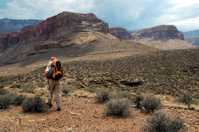
Shortly after the Tonto Trail crosses the main drainage from Horseshoe Mesa between its prongs, we arrived at the intersection with the trail that would take us up through the Redwall. It was about 3:45 pm when we began the ascent through the layers of Bright Angel shale and Muav limestone towards the Redwall. This route is direct and doesn't do much switchbacking until you reach the Redwall. I stopped for a short break at the base of the Redwall. The time was 4:15 pm, I was sweating heavily and starting to feel sapped of energy. Continuing the ascent, I had to take another rest stop halfway through the Redwall. After I assured Dennis I would be fine after a few minutes, he pushed on to the rim of the mesa. I rested for 15 minutes, drank some water and snacked on granola before renewing the push to the top of the Redwall. The time was 4:45 pm when I caught up with Dennis at the top.
It was during this break atop the Redwall that I really began to feel drained by the day's activity. Normally, achieving the Redwall provides a genuine psychological boost. It's a major challenge in any ascent from the Tonto to the rim and getting through the Redwall usually makes me feel as though I'm over the hump; halfway home. But not on this day. I was still feeling drained as we trekked across the mesa to our lower water cache. And it was the thought of reaching that cache that kept my spirits up. We arrived at the lower cache around 5:45 pm. Dennis, who'd cached his bottle in an insulated sleeve, found ice chips floating in his water and volunteered to mix our supplies so I could enjoy the refreshing benefits of chilled water. We rested for 30 minutes, before resuming the ascent.
The hike to the upper water cache started well enough for me. I was moving slowly but, during that initial climb through the Supai group, felt on track to make it out of the canyon in reasonably good shape. We even stopped to chat with two of Dennis' co-workers who were on their way to Horseshoe Mesa for the night. Then we arrived at the switchbacking ascent to the Coconino saddle. I knew that if I were able to finish the climb to the saddle where our upper water cache awaited, I would be OK. But two or three switchbacks from the top, I just had to stop. Sweat was pouring off my face, arms and legs. My gut was aching and I had to get off my feet. Again, I reassured Dennis that I would be OK after a break so, he continued to the water cache. I resumed the trail after a 15 minute rest. It was slow going but knowing that Dennis would be waiting at the Coconino saddle with my water was a real motivation. I'm not certain when I arrived at the saddle but, according to Dennis' hiking log, it was about 7:30 pm
While at the saddle, I realized I was in trouble. This wasn't the usual tiredness, thirst and hunger that comes with a long, hard hike in Grand Canyon. What I was feeling was an almost total loss of energy. And my stomach was simultaneously aching for food and telling me to keep the food out. Knowing the importance of keeping the body fueled, I dug out a granola bar and forced myself to eat. I also drank more water and lay down for a rest. But everything I did required twice as much time as usual. Movement came slowly and decisions also seemed to stall. At this point, we were about 1 mile from the rim. Weighing the options of spending the night at the saddle or continuing with the hike, I opted for continuing with the hike. I was drained and nauseous, but was not suffering from cramps, headaches or feeling dizzy. Also, my body was still doing an adequate job of regulating heat. So, after a half-hour rest, we pushed on.
Which brings me back to the beginning of this report. If I had to guess, I'd guess we'd been climbing through the Coconino for 20 minutes before I stopped to allow the inevitable to unfold. After emptying the contents of my stomach, the nausea was gone and I felt immediately better. I was still physically drained, but at least I wasn't feeling sick to my stomach. It must have taken another 45 minutes to an hour to finish the hike, which concluded at 9:40 pm with our arrival at the Grandview trailhead. As we approached the last switchbacks, it started to rain. The rain flowing over my arms, torso and legs took my mind off the physical challenge of taking the next step. In many respects, that rain was a Godsend. It helped me finish the most difficult hike of my short Grand Canyon hiking life.
So, what happened? Why did I end up suffering from heat exhaustion? I don't think it can be attributed to any single cause. But there are several suspects that may have combined to cause the distress.
And here are two new suspects: The night before the hike, I had two beers with dinner. Later, after getting home from the restaurant, I did my daily 30-minute workout on the treadmill. Could the beer and workout have left me at a moderate level of dehydration, even before I set foot on the Grandview?
Bill Ferris
Flagstaff, Arizona
 |
 |
 |